Two Sides of San Bruno Mountain
I admit it. The real reason I went hiking on the mountain so early was to see a fox. This fox:
(Sorry, you have to follow the link to see the cute little fox baby )
Any wildlife would be welcome though, and I expected to see raptors and rodents. Mountain lions would be the best, even better than foxes, but that seems unlikely. I honestly doubted that I would get to see a fox but, what the hell, I’m a nature-viewing-optimist.
I figured looking for the fox would be best at dawn or dusk since they’re nocturnal or crepuscular ( great word — crepuscular: Appearing or active in twilight ). So I thought, why not increase my odds and try both? The idea then snowballed into this grand concept of “The Two Sides of San Bruno Mountain,” and many possible meanings and comparisons jumped out at me: Top and Bottom, Bike and Hike, East and West, Sunrise and Sunset. Boy, am I clever…
The plan I set forth was this: hike up to the ridge above Brisbane on the southwestern part of the mountain at sunrise, followed by a late afternoon mountain bike ride on the northern portion to the peak at sunset, then compare and contrast and explain and throw in a bit of trivia. But most of all look for foxes.
San Bruno Mountain State and County Park is a special place: 2,416 acres of preserved wildlands within spittin’ distance of San Francisco. It’s surrounded by Daly City, South San Francisco, Colma, and Brisbane. The peak is 1314 ft above sea level. And it’s the park that almost wasn’t.
In 1960 San Bruno Mountain with a total of 3600 acres was owned by the Crocker Land Company. Plans were made to cut off the top of the mountain, throw it in the bay, and build 36,000 houses. After a protracted fight, leading to national legislation and the creation of a prototype of local environmental activism, the park was created and dedicated in 1986 and, in the end, only 386 acres were developed — at least at the time.
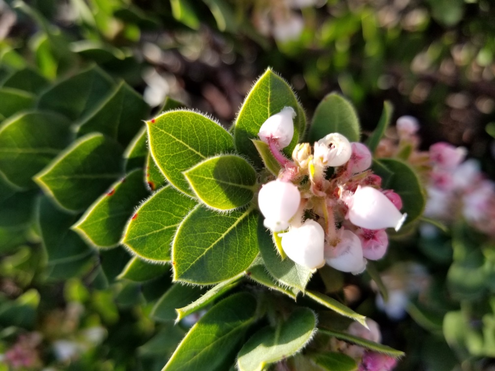
Pulitzer Prize-winning biologist, Edward O. Wilson, has called San Bruno Mountain, “One of 18 global biodiversity ‘hot spots’ in need of immediate protection.” There are 14 plant species, four butterflies, and one snake endemic to San Bruno Mountain all of which are endangered to some degree. However, the inclusion of two of those is at best nature-viewing-optimism. One of the butterflies — the purple owl’s clover eating Bay Checkerspot — hasn’t been seen on the mountain since 1985, and the beautiful, elusive San Francisco Garter Snake doesn’t seem to live there anymore either. Though I swear I saw one once as I whizzed by it on my mountain bike — it had disappeared before I had the time to stop, turn around, and get the phone out. There are 17 Manzanitas endemic to the mountain; two of them are critically endangered — one of which, the Pacific Manzanita, is found nowhere else. I’m fascinated by the manzanita, not only because of hyper-local extremely endangered varieties but for a time, as a child, one was literally a part of me. I was about six, running home in the twilight and I ran past a manzanita bush missing all but one sharp twig that embedded itself in my cheek (you could say it was a crepuscular accident). This twig was in my face for about a year before working its way out, leaving me with a double dimple on my left side. I didn’t end up seeing many manzanitas on this trip, but here’s a picture of what I believe to be the super-endangered Pacific Manzanita on a different hike:
To give us an idea of where we are: the San Bruno massif is an amoeba shaped mass that runs roughly south-east to north-west with Brisbane and South San Francisco squeezing the south-east portion, Daly City draped around the north side, and the cemeteries of Colma propping up the south. Spurs and valleys flow off both sides of the main ridge, but the south side, above South San Francisco, is much steeper and has fewer trails. The main park, parking, and picnic area are on the north side and separated from the bulk of the mountain by Guadalupe Canyon Parkway.
I left the house at 6:00 AM for a 13 min drive (according to Waze) to get on the trail by 6:21 AM — first light — giving me about 1/2 hour to get up into the hills before sunrise. It was just light enough to see when I started hiking, though I did have my headlamp along if needed.
It was cool, but not cold. Perfect for hiking. Too cold to be standing around but comfortable when moving.
The trail went up immediately, and fairly quickly I was in a tunnel made of heavy brush and trees. Based on my Google map recon I didn’t think navigation was going to be difficult. It’s not a very long trail and looked pretty straightforward on the map. However, it turns out there are multiple well maintained trails. Any time the trail forked I tried to take the most obvious one (as Yogi Berra advised, when I came to a fork in the road I took it). I’m not sure where my actual path diverged from the planned path.
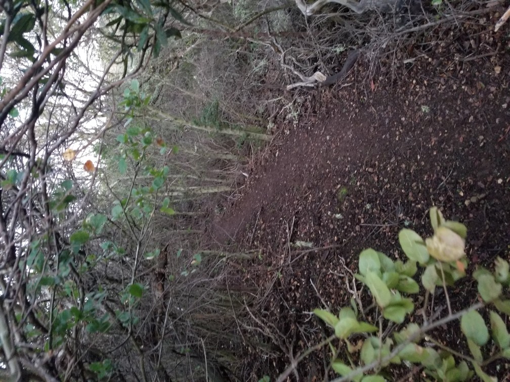
Some parts of the trail had a light layer of mud over hard-packed dirt. Slippery. Parts of the path were so thickly arched with bushes and trees that I had to move in a partial crouch which made me think of Young Frankenstein and “walk this way”. I don’t know how many pounds of spider web I collected throughout the hike. I wasn’t walking through big scary webs completely blocking the path as if to trap humans, but continually getting wrapped by a strand here and a strand there.
It was still mostly dark when the trail dropped down into a ravine. It looked like a cool place to go, lush and perhaps there was a stream in there somewhere. But soon the trail was blocked and guarded by one big bush projecting itself over the path. I hesitated.
I should point out that San Bruno Mountain has LOTS of poison oak in some areas, and I’m very allergic. Remind me to tell you sometime about arriving in Tahiti with legs covered in oozing poison oak pustules. I hadn’t seen any for sure on this hike, but then it was also dark, so.
Anyway, I’m concerned with pushing through the foliage blocking the trail mostly for this reason, also not knowing if there’ll be a payoff on the other side. I ended up going for it. I don’t think there was any poison oak in there; I’ll find out in a day or so. And then the trail ended for real.
I went back, past the bushy blockage, back up the trail, and decided it was high time to look at an actual map. Given my overly optimistic assumptions about navigating on this hike, i.e. little to no preparation, an actual map meant google maps, which, luckily, I had access to. It’s not like this is the wilderness exactly. Turns out I was about halfway in between my intended outgoing trail and my intended return trail.
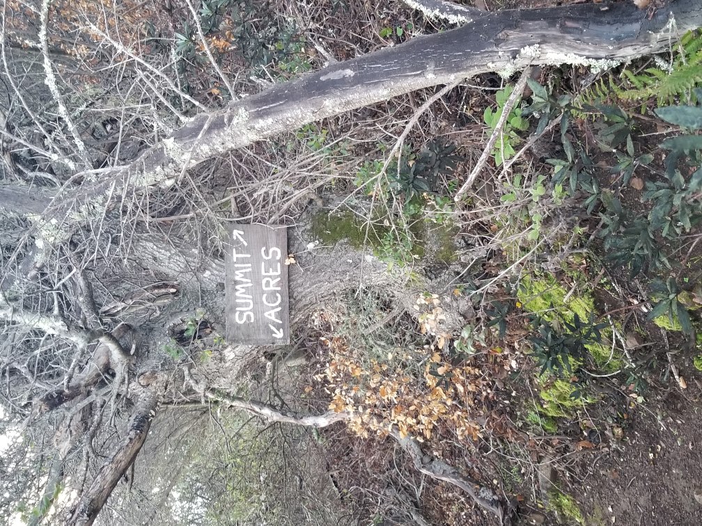
I hiked back down the trail to some trail markers I had passed earlier. One pointed to “Shellmound”, another pointed to “Acres” and “Summit”. I didn’t know what an “Acres” was. “Summit” seemed right as I was heading towards the summit. “Shellmound” was pointed in entirely the wrong direction. Also if “Shellmound” is pointing to THE shell mound then that path is headed towards the bay and the south end of the mountain.
The Siplichiquin shellmound is one of the largest shellmounds in the Bay Area, covering an area of about two acres, and is the oldest known indigenous site in the region. The Ohlone used it as a seasonal village for over 5000 years. It’s most likely the site of Siplichiquin, a village referred to in old mission Dolores records. Of course, as always, it couldn’t just be left in peace but took a huge conservancy fight to keep it from being developed into hotels and parking.
Back on the other other main trail, I hiked south-ish up the side of one of the spurs that drifts off the mountain towards Brisbane. Parts of the trail were steep enough for switchbacks. I was thinking that I’d get to the top of the spur, then follow it up to the summit ridge. The eastern sky was brightening rapidly, and I was still in heavy vegetation but hustling to try to get to a good spot for the sunrise. Glimpses of the bay through the bushes showed a layer of fog at bay level that covered all but the spindly masts on the container ships on the bay and the radio masts of the industrial buildings of Brisbane.
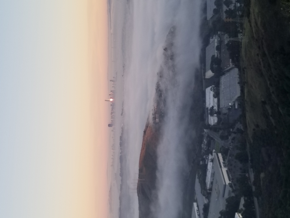
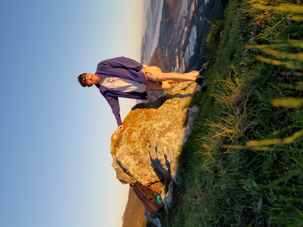
I crested the ridge right at a break in the foliage only to find the sun already up. So, I missed that. I can see north to San Francisco, and it’s also mostly covered in fog. The rising sun reflects off the Salesforce tower like a great big nerd beacon. I turned up towards the summit ridge and had an easy and pleasant hike in the growing dawn light. With such lovely light I had to practice my selfie-timer-skills.
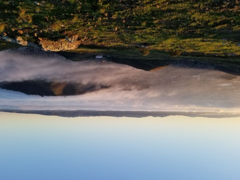
I made it to the top of the ridge and hung a right on the appropriately named Ridge trail (more fire road than trail) which follows along the main spine of the mountain. The spurs and valleys that drop off the ridge were surprisingly steep and green but, aside from a few nooks and crannies, not thickly forested. I walked up the trail towards the peak, the radio towers, and the upper parking lot. To the south I looked down on Sign Hill, the location of the SSF Industrial City sign, Colma, and South San Francisco. The cities and cemeteries were covered in a blanket of fog. It’s mostly grass and scrub up here, with the occasional pocket of thicker bushes and trees in a hollow.
I hiked up the trail, taking my time, meandering side to side to peer over the edge, enjoying the beautiful morning and looking for critters (foxes remember?) but only saw the flying kind. There are many birds of prey up here, in fact.
I saw one place that looked like a nice trail heading down one of the spurs in the direction of my car and found out with a quick Google check that it is in fact my return trail. But, I’m not ready to return yet; so, I continue up the trail a piece, enjoying the scenery and wildlife search.
On the way back I easily found the down trail which heads north-ish along the top of the spur winding amongst mostly grasses and rocks with the occasional bush here and there. It gradually got steeper and filled out with foliage, and in no time I was back in an all-but-tunnel of green. The trail did a quick jag to the left and presented me with another fork to take. I felt that staying on the ridge-following trail would take me on the planned route back, but where’s the adventure in that? I chose the fork with the trail that dove recklessly into the valley thick with vegetation. The farther down I went, the steeper and rockier the trail became with switchbacks and even rock steps. I had some concern that I was heading for a dead end, as I had earlier, and would have to go back up this steep trail. But it continued on and at the bottom I was rewarded with a lovely little stream under lush thick foliage.
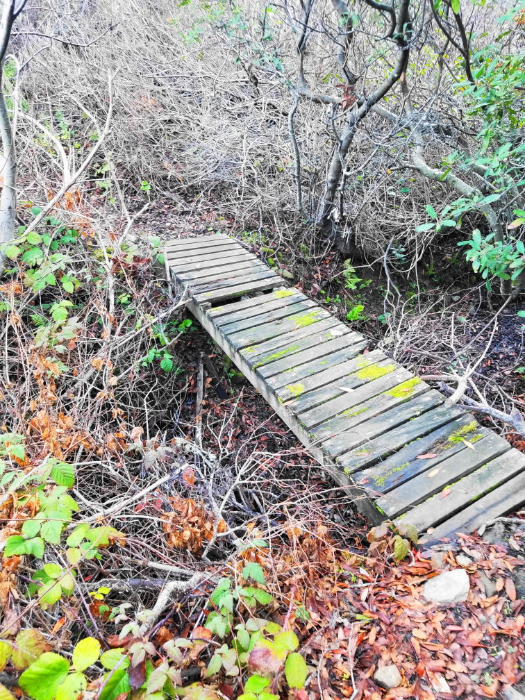
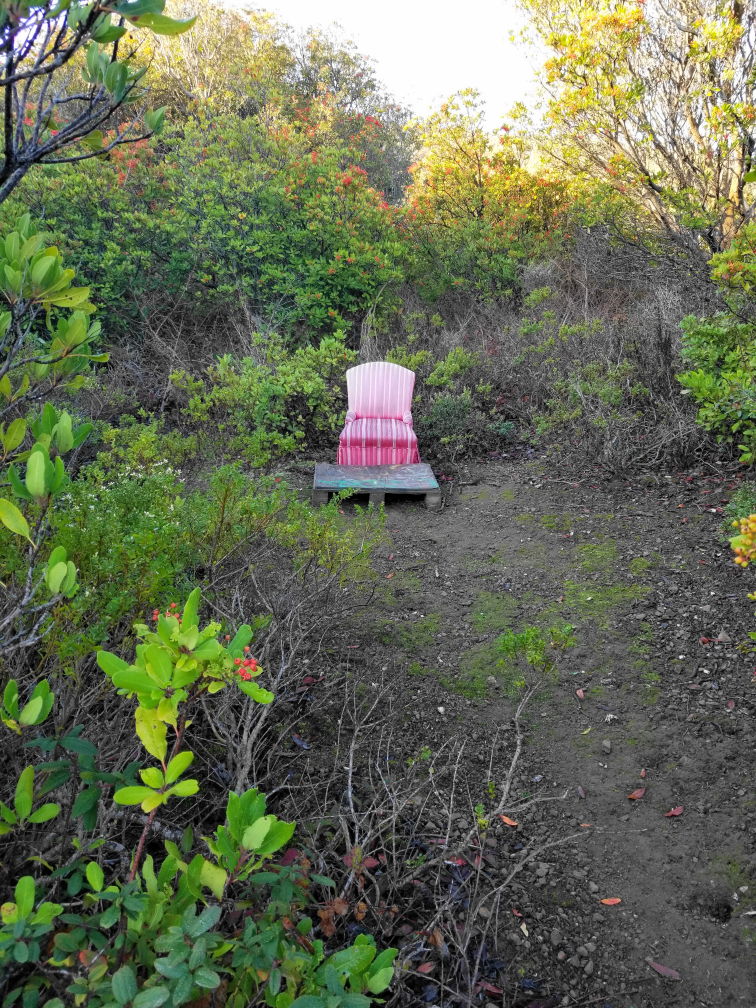
I crossed the crick and continued up the other bank for a short way before I came to yet another fork. This time I took the one that seemed more likely to be going back towards the car. I didn’t think I was that far from the main road at this point. The trail here was flatter, and the foliage was thinning out. I came around a corner and just off the trail was a large living room-sized clearing, fully encircled by trees except for the entrance where I stood, and in the very center of the verdant meadow was a bright pink stuffed armchair. Aha! At last I’ve found the Elven Court!
I made it back to the road and was treated to a beautiful sight; a grassy field of thigh-high grass dotted with bigger tussocks and a few bushes, steam rose in thick tendrils off the ground, the sun was behind the field and the rising moisture caught in numerous spider webs creating a luminous landscape. (I tried to get a picture but I just couldn’t capture the magic).
After-action research told me that the canyon I was in on the way up was Buckeye Canyon and the one I returned through was Owl Canyon. Both are “Temporarily Closed” according to Google maps. And it looked like the outgoing trail I had intended to use is the access road under the power towers and perhaps not the nicest way up. My haphazard route finding may have been roughly correct with the exception of the dead end.
The other side, the north side, the peak side, the bike side, the sunset side.
Most people visiting San Bruno Mountain State Park will enter via the main gate from Guadalupe Canyon Parkway, a road that cuts the mountain in two. Guadalupe Canyon Parkway is a four-lane road that takes you from Daly City on the west side of the mountain to Brisbane on the east side with easy access to the 280 and 101 freeways at the respective ends. It’s well known for being the end of the big car chase in Steve McQueen’s Bullett. Back then it was still dirt. The park entrance is at the highest point of Guadalupe Canyon Parkway, what would be a saddle on the mountain. You turn east into the park and pay your fee at the ranger kiosk ( possibly self-serve), then drive into one of two main parking areas. Immediately adjacent to the first parking lot is a picnicking meadow and various trails heading off in multiple directions. To the east are trails with views of the Bay and SF, to the west are the trails that go to the top of the mountain with even better views.
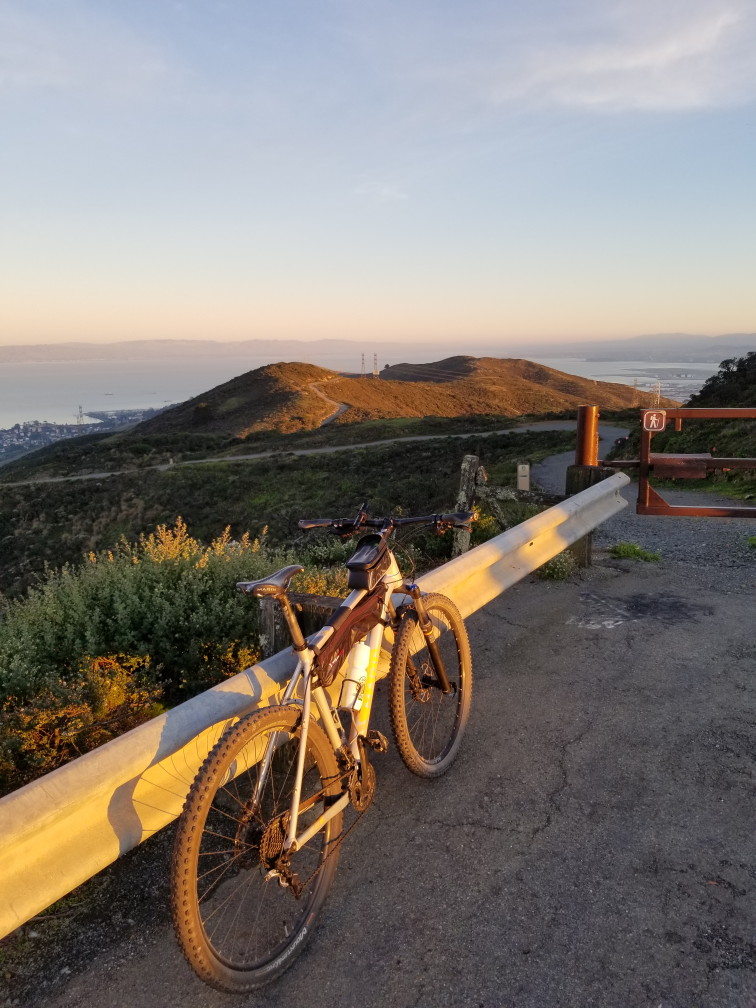
For those of us locals, there is a secret back gate off of Crocker Avenue ( it’s not really secret ) that’s a human-powered entrance only but has plenty of street parking just outside the park. This is the start of my bike ride to the peak. From here it’s 0.8 of a paved mile through a mostly Eucalyptus forest ( some of which is being removed for various environmental and safety reasons ) to the main parking lot. In this part of the park, at this time of day, there are quite a few more people hiking about. I rode through the forest to the main parking area and then up the short connector road, which goes under Guadalupe Canyon Parkway, to the upper parking level. From here, if you’re hiking, there are trails that go in various directions and all save one end up towards the peak.
All of the single-track trails in the park are foot traffic only. As much as I would prefer riding single track to the peak (and even better down from the peak ) the road is my only option. It took about 30 minutes for me to ride from the parking lots to the top, which left me plenty of time before sunset.
The peak itself isn’t particularly attractive as there are 10 major telecommunications towers on it with associated supporting buildings, but the views are incredible.
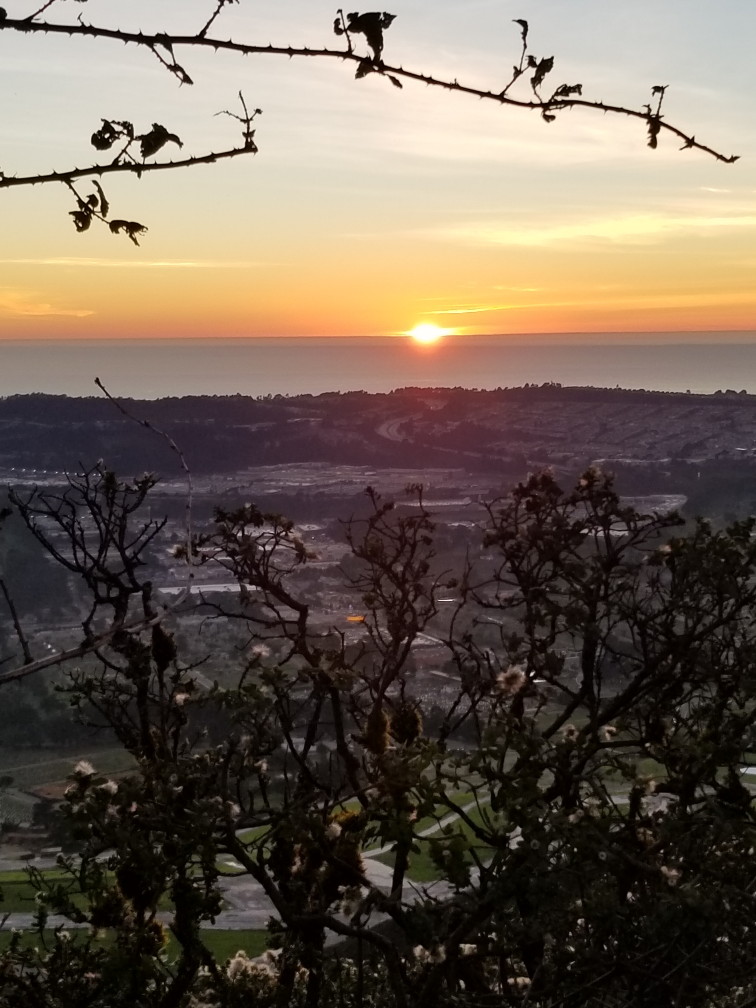
While waiting for the sun to set I practiced my selfie and timer selfie game to no avail. I couldn’t find a good spot toward the setting sun that doesn’t include telecom towers or telephone lines. I did get a good picture of the upper regions of the morning’s hike.
The carpet of fog that obscured SSF, Brisbane, and all points south in the morning had completely dissipated and those cities were laid out in an all but 360-degree carpet around me.
The sun set. I rode back down the hill in the waning light and back to the more populous east of Guadalupe Canyon Parkway section of the park. The bike friendly trails on this side of Guadalupe Canyon Parkway make a big figure eight of roads, some paved, some dirt. I thought I would cruise around a bit in the darkness in a last optimistic gasp of wildlife viewing to see if I could see any creatures. Normally the park closes around sunset but this evening there was some overnight camping event going on.
I went up a small promontory, the highest point on the east side of the park, looking for animals as the light fades. I stumbled around in the dark, or whatever the biking analog to stumbling is, following glimpses of owls and bats. I didn’t see them up close, though I did see them. It’s no longer the crepuscular time of day so time to call it. And the foxes have probably gone to bed by now, or whatever they do after the sun sets, probably clubbing, and I headed home in the dark.
To sum up: Two lovely excursions on the mountain; Views for days; no foxes, no mountain lions, birds galore, raptors, bats, and an owl; a pound of spider webs; a fairy meadow.
Jean Doe
Lorem ipsum dolor sit amet, consectetur adipisicing elit. Pariatur quidem laborum necessitatibus, ipsam impedit vitae autem, eum officia, fugiat saepe enim sapiente iste iure! Quam voluptas earum impedit necessitatibus, nihil?
Reply